Clay, Mississippi
Clay, Mississippi | |
|---|---|
 Clay  Clay | |
| Coordinates: 34°16′12″N 88°20′14″W / 34.27000°N 88.33722°W | |
| Country | United States |
| State | Mississippi |
| County | Itawamba |
| Elevation | 463 ft (141 m) |
| Time zone | UTC-6 (Central (CST)) |
| • Summer (DST) | UTC-5 (CDT) |
| GNIS feature ID | 668531[1] |
Clay is an unincorporated community in Itawamba County, Mississippi, United States.
It is located on Mississippi Highway 178, 4.5 mi (7.2 km) east of Fulton.
Clay had a post office in the early 1900s.[2]
Notes
- ^ "Clay". Geographic Names Information System. United States Geological Survey, United States Department of the Interior.
- ^ Rowland, Dunbar (1907). Mississippi: Comprising Sketches of Counties, Towns, Events, Institutions, and Persons, Arranged in Cyclopedic Form. Vol. 1. Southern Historical Publishing Association. p. 450.
Municipalities and communities of Itawamba County, Mississippi, United States | ||
|---|---|---|
| City | 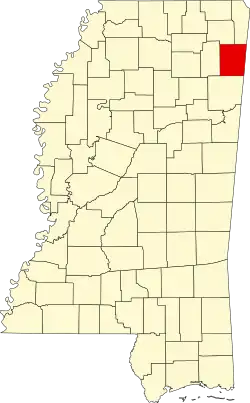 | |
| Towns | ||
| CDP | ||
| Other communities | ||
| Ghost towns | ||