Chkhorotsqu Municipality
Chkhorotsqu Municipality
ჩხოროწყუს მუნიციპალიტეტი | |
|---|---|
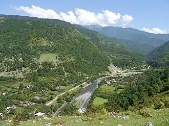 Ochkhomuri River | |
 Flag  Seal | |
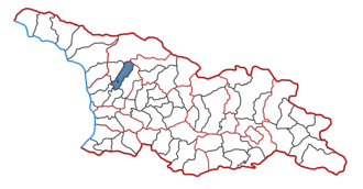 Location of the municipality within Georgia | |
| Country | |
| Region | Samegrelo-Zemo Svaneti |
| Administrative centre | Chkhorotsqu |
| Government | |
| • Body | Chkhorotsqu Municipal Assembly |
| • Mayor | Dato Gogua |
| Area | |
• Total | 619.4 km2 (239.2 sq mi) |
| Population (2014) | |
• Total | 22,309 |
| • Density | 36.0/km2 (93/sq mi) |
| Population by ethnicity[1] | |
| • Georgians | 99,70 % |
| • Russians | 0,17 % |
| • Ukrainians | 0.04 % |
| • Armenians | 0,03 % |
| Time zone | UTC+4 (Georgian Standard Time) |
| Website | http://www.chkhorotsku.gov.ge/ge |
Chkhorotsqu or Chkhorotsku (Georgian: ჩხოროწყუს მუნიციპალიტეტი, Çxoroċqus municiṗaliṫeṫi) is a district of Georgia, in the region of Samegrelo-Zemo Svaneti. Its main town is Chkhorotsqu.
Population: 22,309 (2014 census)
Area: 619 km2
Politics
Chkhorotsqu Municipal Assembly (Georgian: ჩხოროწყუს საკრებულო) is a representative body in Chkhorotsqu Municipality, consisting of 27 members which is elected every four years. The last election was held in October 2021. Dato Gogua of Georgian Dream was re-elected mayor in a tight 2nd round against a candidate of the United National Movement. Chkhorotsqu was one of only seven municipalities where ruling Georgian Dream party failed to secure a majority. After several attempts, the opposition parties UNM, For Georgia and Lelo agreed on a chair of the Sakrebulo, but key party For Georgia denied it formed a coalition with any of the other parties.[2][3]
| Party | 2017[4] | 2021[5] | Current Municipal Assembly | |||||||||||||||||||||||||||||||||||||||||||||
|---|---|---|---|---|---|---|---|---|---|---|---|---|---|---|---|---|---|---|---|---|---|---|---|---|---|---|---|---|---|---|---|---|---|---|---|---|---|---|---|---|---|---|---|---|---|---|---|---|
| Georgian Dream | 19 | 12 | ||||||||||||||||||||||||||||||||||||||||||||||
| United National Movement | 4 | 7 | ||||||||||||||||||||||||||||||||||||||||||||||
| For Georgia | 1[a] | 6 | ||||||||||||||||||||||||||||||||||||||||||||||
| Lelo | 1 | |||||||||||||||||||||||||||||||||||||||||||||||
| Independent | 1[b] | |||||||||||||||||||||||||||||||||||||||||||||||
| Development Movement | 2 | |||||||||||||||||||||||||||||||||||||||||||||||
| European Georgia | 1 | |||||||||||||||||||||||||||||||||||||||||||||||
| Alliance of Patriots | 1 | |||||||||||||||||||||||||||||||||||||||||||||||
| Total | 28 | 27 | ||||||||||||||||||||||||||||||||||||||||||||||
Administrative divisions
Chkhorotsqu municipality is divided into one borough (დაბა, daba) and 12 villages (სოფელი, sopeli):[8]
Boroughs
Villages
- Mukhuri
- Zumi
- Taia
- Khabume
- Kveda chkhorotsqu
- Lesichine
- Letsurtsume
- Kirtskhi
- Nakiani
- Akhuti
- Napichkhovo
- Chogha
See also
Explanatory notes
References
- ^ "Ethnic composition of Georgia 2014". mashke.org. Archived from the original on 2018-11-04.
- ^ "Opposition Elects Chair in Hung Chkhorotsku Sakrebulo". Civil.ge. 2021-12-23. Retrieved 2022-01-19.
- ^ "We are not forming an alliance with other opposition parties - Chkhorotsku Sakrebulo Chairman". droa.ge (in Georgian). 2021-12-23. Retrieved 2022-01-19.
- ^ "Protocol elected municipal council members and mayors 2017" (PDF) (in Georgian). CESKO Central Election Commission. pp. 90–91. Retrieved 2021-01-06.
- ^ "Protocol elected municipal council members and mayors 2021" (PDF) (in Georgian). CESKO Central Election Commission. pp. 110–112. Retrieved 2021-01-06.
- ^ "ქართული ოცნება ჩხოროწყუს საკრებულოს წევრმა დატოვა და გახარიას გუნდს შეუერთდა". Formulanews (in Georgian). 2021-08-04. Retrieved 2024-06-18.
- ^ "ჩხოროწყუს საკრებულოს წევრი გახარიას პარტიას ტოვებს". Netgazeti (in Georgian). 2021-12-27. Retrieved 2024-06-18.
- ^ "ჩხოროწყუს მუნიციპალიტეტის საკრებულო". www.chkhorotsku-sakrebulo.ge. Archived from the original on 2017-02-27. Retrieved 2017-02-27.
External links
- Districts of Georgia, Statoids.com
| Autonomous Republic of Abkhazia | |
|---|---|
| Autonomous Republic of Adjara | |
| Guria | |
| Imereti | |
| Kakheti | |
| Mtskheta-Mtianeti | |
| Racha-Lechkhumi and Kvemo Svaneti | |
| Samegrelo-Zemo Svaneti | |
| Samtskhe-Javakheti | |
| Kvemo Kartli | |
| Shida Kartli | |
42°30′37″N 42°07′45″E / 42.51028°N 42.12917°E