Chester Gap, Virginia
Chester Gap, Virginia | |
|---|---|
Census-designated place (CDP) | |
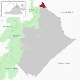 Location of the Chester Gap CDP within Rappahannock County | |
 Location within the Commonwealth of Virginia  Chester Gap, Virginia (the United States) | |
| Coordinates: 38°51′12″N 78°7′57″W / 38.85333°N 78.13250°W | |
| Country | United States |
| State | Virginia |
| County | Rappahannock |
| Elevation | 1,526 ft (465 m) |
| Population | |
• Total | 894 |
| Time zone | UTC-5 (Eastern (EST)) |
| • Summer (DST) | UTC-4 (EDT) |
| ZIP code | 22623 |
| Area code | 540 |
| FIPS code | 51-16240 |
| GNIS feature ID | 2630625 |
Chester Gap is a census-designated place (CDP) in Rappahannock and Warren Counties, Virginia, United States. The population as of the 2010 Census was 839.[1] The CDP is named for Chester Gap, the wind gap within which it is located.
Demographics
| Census | Pop. | Note | %± |
|---|---|---|---|
| 2020 | 894 | — | |
| U.S. Decennial Census[2] 2010[3] 2020 | |||
Chester Gap was first listed as a census designated place in the 2010 U.S. Census.[3]
References
- ^ "SAS Output". Archived from the original on July 11, 2012. Retrieved June 9, 2011.
- ^ "Decennial Census by Decade". United States Census Bureau.
- ^ a b "2010 Census of Population - Population and Housing Unit Counts - Virginia" (PDF). United States Census Bureau.
Municipalities and communities of Rappahannock County, Virginia, United States | ||
|---|---|---|
| Town | 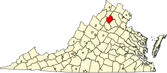 | |
| CDPs | ||
| Unincorporated communities | ||
| Footnotes | ‡This populated place also has portions in an adjacent county or counties | |
Municipalities and communities of Warren County, Virginia, United States | ||
|---|---|---|
| Town | 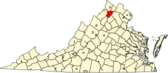 | |
| CDPs | ||
| Other communities | ||
| Footnotes | ‡This populated place also has portions in an adjacent county or counties | |