Chenoweth, Ohio
Chenoweth, Ohio | |
|---|---|
 Chenoweth  Chenoweth | |
| Coordinates: 39°43′52″N 83°21′27″W / 39.73111°N 83.35750°W | |
| Country | United States |
| State | Ohio |
| Counties | Madison |
| Township | Range |
| Elevation | 951 ft (290 m) |
| Time zone | UTC-5 (Eastern (EST)) |
| • Summer (DST) | UTC-4 (EDT) |
| ZIP Code | 43143 (Mount Sterling) |
| Area code | 740 |
| GNIS feature ID | 1056240[1] |
Chenoweth is an unincorporated community in Range Township, Madison County, Ohio, United States. It is located along Ohio State Route 323 between McClimansville and Range.[2]
Chenoweth was never platted.[3] The community has the name of John Chenoweth, a pioneer settler.[4] The Chenoweth Post office was established on October 12, 1887, but was discontinued on September 15, 1900. The mail service is now sent through the Mount Sterling branch.[5] As of 1915, the community contained one grocery store, one blacksmith, and a small cluster of houses.[3]
References
- ^ a b U.S. Geological Survey Geographic Names Information System: Chenoweth, Ohio
- ^ Rand McNally, The Road Atlas, Chicago, Rand McNally, 2006, p.80.
- ^ a b Bryan, Chester E., History of Madison County, Ohio, B.F. Bowen & Company, Inc., Indianapolis, Indiana, 1915, Pg. 186.
- ^ Overman, William Daniel (1958). Ohio Town Names. Akron, OH: Atlantic Press. p. 26.
- ^ U.S. Geological Survey Geographic Names Information System: Chenoweth Post Office
Municipalities and communities of Madison County, Ohio, United States | ||
|---|---|---|
| City | 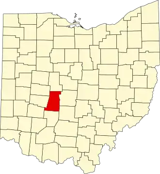 | |
| Villages | ||
| Townships | ||
| CDPs | ||
| Unincorporated communities | ||
| Footnotes | ‡This populated place also has portions in an adjacent county or counties | |