Carlson, Texas
Carlson, Texas | |
|---|---|
 Carlson  Carlson | |
| Coordinates: 30°25′40″N 97°27′7″W / 30.42778°N 97.45194°W | |
| Country | United States |
| State | Texas |
| County | Travis |
| Elevation | 571 ft (174 m) |
| Time zone | UTC-6 (Central (CST)) |
| • Summer (DST) | UTC-5 (CDT) |
| Area codes | 512 & 737 |
| GNIS feature ID | 1353827[1] |
Carlson is an unincorporated community in Travis County, in the U.S. state of Texas.[1] According to the Handbook of Texas, the community had a population of 61 in 2000. It is located within the Greater Austin metropolitan area.
History
Carlson was possibly named after local residents. The population was 61 in 1972 and 2000.[2]
On April 30, 1954, an F3 tornado struck Carlson.[3]
Geography
Carlson is located near Farm to Market Road 973, 9 mi (14 km) east of Pflugerville in northeastern Travis County.[2]
Education
Today the community is served by the Elgin Independent School District. Schools that serve the community are Neidig Elementary School, Elgin Middle School, and Elgin High School.
References
- ^ a b U.S. Geological Survey Geographic Names Information System: Carlson, Texas
- ^ a b Carlson, TX from the Handbook of Texas Online
- ^ Multiple sources:
Sources
- Grazulis, Thomas P. (July 1993). Significant Tornadoes 1680–1991: A Chronology and Analysis of Events. St. Johnsbury, Vermont: The Tornado Project of Environmental Films. ISBN 1-879362-03-1.
- National Weather Service (April–June 1954). Storm Data Publication (Report). National Centers for Environmental Information – via Storm Events Database.
- U.S. Weather Bureau (April 1954). "Storm data and unusual weather phenomena". Climatological Data National Summary. 5 (4). Asheville, North Carolina: National Climatic Data Center: 106–115.
Municipalities and communities of Travis County, Texas, United States | ||
|---|---|---|
| Cities | 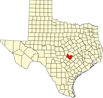 | |
| Villages | ||
| CDPs |
| |
| Other communities | ||
| Ghost towns |
| |
| Footnotes | ‡This populated place also has portions in an adjacent county or counties | |