Burnt Chimney, Virginia
Burnt Chimney, Virginia | |
|---|---|
_between_Saddlewood_Drive_(Virginia_State_Secondary_Route_1000)_and_Four_Corners_Court_in_Burnt_Chimney%252C_Franklin_County%252C_Virginia.jpg) View north along Virginia State Route 116 (Jubal Early Highway) between Saddlewood Drive (Virginia State Secondary Route 1000) and Four Corners Court in Burnt Chimney | |
 Burnt Chimney  Burnt Chimney | |
| Coordinates: 37°6′19″N 79°48′56″W / 37.10528°N 79.81556°W | |
| Country | United States |
| State | Virginia |
| County | Franklin |
| Elevation | 1,129 ft (344 m) |
| Time zone | UTC-5 (Eastern (EST)) |
| • Summer (DST) | UTC-4 (EDT) |
| GNIS feature ID | 1477160[1] |
Burnt Chimney (also called Reverie) is an unincorporated community in Franklin County, Virginia, United States. A farm named Waverly was listed on the National Register of Historic Places in 1996.[2]
References
Wikimedia Commons has media related to Burnt Chimney, Virginia.
Municipalities and communities of Franklin County, Virginia, United States | ||
|---|---|---|
| Towns | 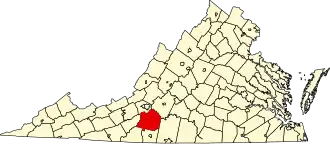 | |
| CDPs | ||
| Unincorporated communities | ||