Brushwood, New South Wales
| Brushwood New South Wales | |
|---|---|
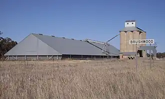 Silos at Brushwood | |
 Brushwood | |
| Coordinates | 34°48′S 147°06′E / 34.800°S 147.100°E |
| Location |
|
| LGA(s) | Coolamon Shire |
| County | Bourke |
| State electorate(s) | Cootamundra |
| Federal division(s) | Division of Riverina |
Brushwood is a rural community in the central east part of the Riverina region of New South Wales, Australia.[2] It is situated by road about 6 kilometres (3.7 mi) east of Ganmain and 8 kilometres (5.0 mi) west of Coolamon.
Brushwood lies within the wheat farming belt of the Coolamon Shire Council and is the home of a small railway station (for the uploading of wheat and other grains) and a series of large 30-metre (98 ft) silos.
References
- ^ Travelmate Archived 24 March 2007 at the Wayback Machine
- ^ "Brushwood". Geographical Names Register (GNR) of NSW. Geographical Names Board of New South Wales.
External links
![]() Media related to Brushwood, New South Wales at Wikimedia Commons
Media related to Brushwood, New South Wales at Wikimedia Commons