Brock, Oklahoma
Brock | |
|---|---|
 Brock Location within the state of Oklahoma  Brock Brock (the United States) | |
| Coordinates: 34°06′57″N 97°14′22″W / 34.11583°N 97.23944°W | |
| Country | United States |
| State | Oklahoma |
| County | Carter |
| Elevation | 922 ft (281 m) |
| Time zone | UTC-6 (Central (CST)) |
| • Summer (DST) | UTC-5 (CDT) |
| GNIS feature ID | 1090507[1] |
Brock is an unincorporated community located in Carter County, Oklahoma, United States. It is about 9 miles southwest of Ardmore.[2] The locale is old enough to appear on a 1911 Rand McNally map of the county.[3]
References
- ^ a b U.S. Geological Survey Geographic Names Information System: Brock, Oklahoma
- ^ "Ardmore, Oklahoma to Brock, Oklahoma". Google Maps. Retrieved March 8, 2025.
- ^ "Carter County, Oklahoma 1911 Map". Rand McNally (accessed on MyGenealogyHound website). Retrieved March 7, 2025.
Municipalities and communities of Carter County, Oklahoma, United States | ||
|---|---|---|
| Cities | 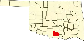 | |
| Towns | ||
| CDP | ||
| Other communities | ||
| Ghost towns | ||
| Indian reservation | ||
| Footnotes | ‡This populated place also has portions in an adjacent county or counties | |