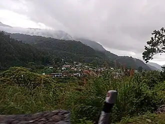
Bhimphedi Rural Municipality
Bhimphedi (RM)
भीमफेदी गाउँपालिका | |
|---|---|
 | |
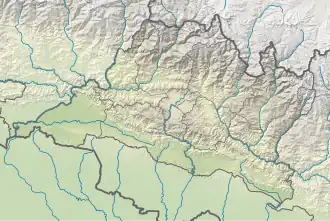 Bhimphedi (RM) Location 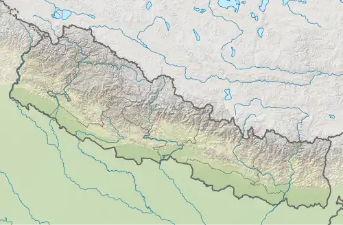 Bhimphedi (RM) Bhimphedi (RM) (Nepal) | |
| Coordinates: 27°33′0″N 85°7′30″E / 27.55000°N 85.12500°E | |
| Country | |
| Province | Bagmati |
| District | Makawanpur |
| Wards | 9 |
| Established | 10 March 2017 |
| Government | |
| • Type | Rural Council |
| • Chairperson | Mr. Hidam Lama |
| • Vice-chairperson | Mrs. Parvati Rana |
| • Term of office | (2017 - 2022) |
| Area | |
• Total | 245.27 km2 (94.70 sq mi) |
| Population (2011) | |
• Total | 23,344 |
| • Density | 95/km2 (250/sq mi) |
| Time zone | UTC+5:45 (Nepal Standard Time) |
| Previous Headquarter | Bhimphedi |
| Website | bhimphedimun |
Bhimphedi is a Rural municipality located within the Makawanpur District of the Bagmati Province of Nepal. The rural municipality spans 245.27 square kilometres (94.70 sq mi) of area, with a total population of 23,344 according to the 2011 Nepal census.[1][2]
On March 10, 2017, the Government of Nepal restructured the local level bodies into 753 new local level structures.[3][4] The previous Bhimphedi, Bhainse, Nibuwatar, Kogate, Ipa Panchakanya and portion of Namtar VDCs were merged to form Bhimphedi Rural Municipality. Bhimphedi is divided into 9 wards, with Bhimphedi VDC declared the administrative center of the rural municipality.
Demographics
At the time of the 2011 Nepal census, Bhimphedi Rural Municipality had a population of 24,960. Of these, 55.4% spoke Tamang, 39.8% Nepali, 1.6% Newar, 1.3% Chepang, 0.7% Magar, 0.6% Maithili, 0.2% Bhojpuri, 0.1% Rai, 0.1% Tharu and 0.1% other languages as their first language.[5]
In terms of ethnicity/caste, 58.9% were Tamang, 14.2% Magar, 7.3% Hill Brahmin, 7.0% Chhetri, 3.3% Chepang/Praja, 3.3% Newar, 2.9% Kami, 0.7% Damai/Dholi, 0.4% Rai, 0.3% Gurung, 0.3% Sunuwar, 0.2% Sarki, 0.1% Terai Brahmin, 0.1% Gharti/Bhujel, 0.1% Kathabaniyan, 0.1% Koiri/Kushwaha, 0.1% Musalman, 0.1% Teli, 0.1% Thakuri, 0.1% Tharu, 0.1% Yadav and 0.4% others.[6]
In terms of religion, 51.9% were Buddhist, 43.9% Hindu, 3.4% Christian, 0.2% Prakriti, 0.1% Muslim and 0.4% others.[7]
In terms of literacy, 66.4% could read and write, 3.0% could only read and 30.5% could neither read nor write.[8]
References
- ^ "District Corrected Last for RAJAPATRA" (PDF). www.mofald.gov.np. Retrieved 17 July 2018.
- ^ "स्थानीय तहहरुको विवरण" [Details of the local level bodies]. www.mofald.gov.np/en (in Nepali). Ministry of Federal Affairs and Local Development. Retrieved 17 July 2018.
- ^ "New local level structure comes into effect from today". www.thehimalayantimes.com. The Himalayan Times. 10 March 2017. Retrieved 17 July 2018.
- ^ "New local level units come into existence". www.kathmandupost.ekantipur.com. 11 March 2017. Retrieved 18 July 2018.
- ^ NepalMap Language [1]
- ^ NepalMap Caste [2]
- ^ NepalMap Religion [3]
- ^ NepalMap Literacy [4]
External links
Headquarters: Hetauda | ||
| Sub-metropolitan cities | 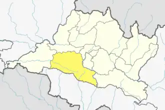 | |
| Municipalities | ||
| Rural municipalities | ||