Bagtown, Maryland
Bagtown, Maryland | |
|---|---|
 Bagtown, Maryland  Bagtown, Maryland | |
| Coordinates: 39°34′54″N 77°36′38″W / 39.58167°N 77.61056°W | |
| Country | United States |
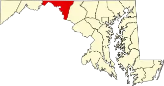
| State | Maryland |
| County | Washington |
| Area | |
• Total | 0.55 sq mi (1.41 km2) |
| • Land | 0.55 sq mi (1.41 km2) |
| • Water | 0.00 sq mi (0.00 km2) |
| Elevation | 689 ft (210 m) |
| Population (2020) | |
• Total | 321 |
| • Density | 587.91/sq mi (227.14/km2) |
| Time zone | UTC−5 (Eastern (EST)) |
| • Summer (DST) | UTC−4 (EDT) |
| Area codes | 301, 240 |
| FIPS code | 24-03514 |
| GNIS feature ID | 2583574[2] |
Bagtown is an unincorporated community and census-designated place in Washington County, Maryland, United States. Its population was 333 as of the 2010 census.[3]
Geography
According to the U.S. Census Bureau, the community has an area of 0.546 square miles (1.41 km2), all land.[3]
Demographics
| Census | Pop. | Note | %± |
|---|---|---|---|
| 2020 | 321 | — | |
| U.S. Decennial Census[4] | |||
References
- ^ "2020 U.S. Gazetteer Files". United States Census Bureau. Retrieved April 26, 2022.
- ^ a b U.S. Geological Survey Geographic Names Information System: Bagtown, Maryland
- ^ a b "2010 Census Gazetteer Files - Places: Maryland". U.S. Census Bureau. Retrieved February 1, 2017.
- ^ "Census of Population and Housing". Census.gov. Retrieved June 4, 2016.