Bắc Mê district
Bắc Mê district
Huyện Bắc Mê | |
|---|---|
| Country | |
| Region | Northeast |
| Province | Hà Giang |
| Capital | Yên Phú |
| Population (2019) | |
• Total | 54 592 [1] |
| Time zone | UTC+7 (Indochina Time) |
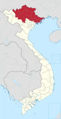
Bắc Mê is a rural district of Hà Giang province in the Northeast region of Vietnam. As of 2019, the district had a population of 54 592.[1] The district covers an area of 844 km2. The district capital lies at Yên Phú.[2]
Administrative divisions
Bắc Mê District consists of the district capital, Yên Phú, and 12 communes: Đường Âm, Đường Hồng, Giáp Trung, Lạc Nông, Minh Ngọc, Minh Sơn, Phiêng Luông, Phú Nam, Thượng Tân, Yên Cường, Yên Định and Yên Phong.
Climate
| Climate data for Bắc Mê | |||||||||||||
|---|---|---|---|---|---|---|---|---|---|---|---|---|---|
| Month | Jan | Feb | Mar | Apr | May | Jun | Jul | Aug | Sep | Oct | Nov | Dec | Year |
| Record high °C (°F) | 32.3 (90.1) |
35.5 (95.9) |
37.8 (100.0) |
40.2 (104.4) |
41.6 (106.9) |
40.0 (104.0) |
39.8 (103.6) |
39.0 (102.2) |
38.2 (100.8) |
36.4 (97.5) |
33.8 (92.8) |
31.8 (89.2) |
41.6 (106.9) |
| Mean daily maximum °C (°F) | 19.7 (67.5) |
21.5 (70.7) |
24.9 (76.8) |
29.0 (84.2) |
31.9 (89.4) |
32.7 (90.9) |
32.8 (91.0) |
33.0 (91.4) |
31.8 (89.2) |
28.7 (83.7) |
25.1 (77.2) |
21.5 (70.7) |
27.7 (81.9) |
| Daily mean °C (°F) | 15.0 (59.0) |
16.7 (62.1) |
19.9 (67.8) |
23.6 (74.5) |
26.0 (78.8) |
27.2 (81.0) |
27.3 (81.1) |
27.0 (80.6) |
25.6 (78.1) |
22.8 (73.0) |
19.2 (66.6) |
15.7 (60.3) |
22.2 (72.0) |
| Mean daily minimum °C (°F) | 12.4 (54.3) |
13.9 (57.0) |
16.8 (62.2) |
20.1 (68.2) |
22.3 (72.1) |
23.9 (75.0) |
24.1 (75.4) |
23.8 (74.8) |
22.2 (72.0) |
19.7 (67.5) |
16.1 (61.0) |
12.5 (54.5) |
19.0 (66.2) |
| Record low °C (°F) | 0.3 (32.5) |
1.4 (34.5) |
4.2 (39.6) |
10.0 (50.0) |
13.9 (57.0) |
15.6 (60.1) |
19.1 (66.4) |
20.0 (68.0) |
13.2 (55.8) |
8.7 (47.7) |
4.6 (40.3) |
−0.1 (31.8) |
−0.1 (31.8) |
| Average precipitation mm (inches) | 29.3 (1.15) |
26.0 (1.02) |
49.4 (1.94) |
89.9 (3.54) |
230.4 (9.07) |
308.6 (12.15) |
339.4 (13.36) |
261.8 (10.31) |
143.9 (5.67) |
88.4 (3.48) |
50.5 (1.99) |
25.1 (0.99) |
1,642.4 (64.66) |
| Average rainy days | 7.8 | 7.0 | 8.6 | 11.9 | 16.9 | 19.8 | 22.1 | 19.1 | 12.8 | 10.7 | 8.7 | 5.9 | 150.9 |
| Average relative humidity (%) | 83.5 | 81.6 | 80.5 | 80.4 | 81.7 | 85.4 | 86.7 | 86.5 | 85.4 | 85.0 | 84.6 | 83.5 | 83.7 |
| Source: Vietnam Institute for Building Science and Technology[3] | |||||||||||||
References
- ^ a b General Statistics Office of Vietnam (2019). "Completed Results of the 2019 Viet Nam Population and Housing Census" (PDF). Statistical Publishing House (Vietnam). ISBN 978-604-75-1532-5.
- ^ "Districts of Vietnam". Statoids. Archived from the original on 1 March 2009. Retrieved March 13, 2009.
- ^ "Vietnam Institute for Building Science and Technology" (PDF). Retrieved 16 August 2023.