Bělá (Semily District)
Bělá | |
|---|---|
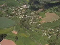 Aerial view | |
 Flag  Coat of arms | |
 Bělá Location in the Czech Republic | |
| Coordinates: 50°32′2″N 15°26′42″E / 50.53389°N 15.44500°E | |
| Country | |
| Region | Liberec |
| District | Semily |
| First mentioned | 1542 |
| Area | |
• Total | 7.76 km2 (3.00 sq mi) |
| Elevation | 378 m (1,240 ft) |
| Population (2025-01-01)[1] | |
• Total | 285 |
| • Density | 37/km2 (95/sq mi) |
| Time zone | UTC+1 (CET) |
| • Summer (DST) | UTC+2 (CEST) |
| Postal code | 514 01 |
| Website | www |
Bělá is a municipality and village in Semily District in the Liberec Region of the Czech Republic. It has about 300 inhabitants.
Demographics
| Year | Pop. | ±% |
|---|---|---|
| 1869 | 847 | — |
| 1880 | 868 | +2.5% |
| 1890 | 822 | −5.3% |
| 1900 | 747 | −9.1% |
| 1910 | 762 | +2.0% |
| 1921 | 665 | −12.7% |
| 1930 | 651 | −2.1% |
| 1950 | 432 | −33.6% |
| 1961 | 413 | −4.4% |
| 1970 | 334 | −19.1% |
| 1980 | 304 | −9.0% |
| 1991 | 278 | −8.6% |
| 2001 | 256 | −7.9% |
| 2011 | 251 | −2.0% |
| 2021 | 260 | +3.6% |
| Source: Censuses[2][3] | ||
References
- ^ "Population of Municipalities – 1 January 2025". Czech Statistical Office. 2025-05-16.
- ^ "Historický lexikon obcí České republiky 1869–2011" (in Czech). Czech Statistical Office. 2015-12-21.
- ^ "Population Census 2021: Population by sex". Public Database. Czech Statistical Office. 2021-03-27.
External links
Wikimedia Commons has media related to Bělá (Semily District).