Bácsbokod
Bácsbokod
Bikić, Wikitsch | |
|---|---|
Large village | |
 Coat of arms | |
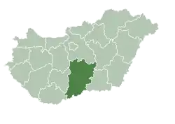
 Bácsbokod Location of Bácsbokod in Hungary | |
| Coordinates: 46°07′19″N 19°09′32″E / 46.1219°N 19.1589°E | |
| Country | Hungary |
| County | Bács-Kiskun |
| District | Bácsalmás |
| Area | |
• Total | 63.93 km2 (24.68 sq mi) |
| Population (2015) | |
• Total | 2,567 |
| • Density | 40/km2 (100/sq mi) |
| Time zone | UTC+1 (CET) |
| • Summer (DST) | UTC+2 (CEST) |
| Postal code | 6453 |
| Area code | (+36) 79 |
Bácsbokod (Croatian: Bikić; German: Wikitsch) is a large village and municipality in Bács-Kiskun County, in the Southern Great Plain region of southern Hungary. The Danube River (River Duna) flows 20 kilometers to the west of the village.[1]
At the end of the 19th century and the beginning of the 20th century, Jews lived in Bácsbokod.[2] In 1910, 29 Jews lived in Bácsbokod, Some of them were murdered in the Holocaust.[3]
Geography
It covers an area of 63.93 km2 (25 sq mi) and has a population of about 3101 people.[1]
Demography
Existing ethnicities:
References
- ^ a b "Bácsbokod" Archived 2017-08-15 at the Wayback Machine. National and historical symbols of Hungary (An official site of the Hungarian Government). Retrieved 12 February 2010.
- ^ Hungarian Jewish census
- ^ Documentation of the village's Jews murdered in the Holocaust
External links
![]() Media related to Bácsbokod at Wikimedia Commons
Media related to Bácsbokod at Wikimedia Commons
- Official website in Hungarian
| Town (1) |
| |
|---|---|---|
| Large village (1) | ||
| Villages (8) | ||