Andoung Meas District
Andoung Meas
អណ្តូងមាស | |
|---|---|
District | |
 Andoung Meas | |
| Coordinates: 13°52′51″N 107°20′51″E / 13.8807°N 107.3474°E | |
| Country | |
| Province | Ratanakiri Province |
| Population (1998) | |
• Total | 6,896 |
| Time zone | UTC+7 (GMT + 7) |
Andoung Meas District (Khmer: អណ្តូងមាស; "Well of Gold") is a district in north-eastern Cambodia, located in Ratanakiri Province, with a population of 6,896 (1998).[1]
Administration
Andoung Meas district is subdivided into four communes (khum),[2] which are further subdivided into 21 villages (phum).
| Khum (commune) | Phum (villages) |
|---|---|
| Malik (commune) | Malik, Katae, Ka Hal, Loum |
| Mai Hie | Tang Chi, Dal, Tang Se, Nhang |
| Nhang | Ka Chut, Nay, Muy, Peng, Chang, Ta Nga, Chay, Ket |
| Ta Lav | Ta Lav, In, Ka Nat, Katae, Ka Nong |
References
- ^ "Rotanak Kiri Provincial Resources" Archived August 31, 2004, at the Wayback Machine. Cambodia National and Provincial Resources Data Bank (2003). Accessed May 5, 2008.
- ^ National Institute of Statistics
Capital city: Banlung | |||||||||||||||||||
| Landmarks | 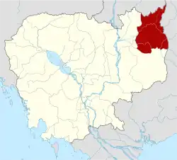 | ||||||||||||||||||
| Administrative divisions |
| ||||||||||||||||||
13°52′51″N 107°20′51″E / 13.8807°N 107.3474°E
| Autonomous municipality |
| ||
|---|---|---|---|
| Provinces | |||