Altura, Archuleta County, Colorado
Altura, Colorado | |
|---|---|
 Altura Location of Altura, Colorado.  Altura Altura (Colorado) | |
| Coordinates: 37°11′00″N 107°11′28″W / 37.18333°N 107.1912°W[2] | |
| Country | United States |
| State | Colorado |
| County | Archuleta[1] |
| Tribe | Southern Ute Indian Tribe |
| Government | |
| • Type | unincorporated community |
| • Body | Archuleta County[1] |
| Elevation | 7,159 ft (2,182 m) |
| Time zone | UTC−07:00 (MST) |
| • Summer (DST) | UTC−06:00 (MDT) |
| GNIS pop ID | 184567 |
Altura is an unincorporated community on the Southern Ute Indian Reservation in Archuleta County, Colorado, United States.[2]
History
The Southern Ute Indian Reservation was created on November 9, 1878.[3] Archuleta County was created on April 14, 1885.[1]
Geography
Altura is located in Archuleta County at coordinates 37°11′00″N 107°11′28″W / 37.18333°N 107.1912°W at an elevation of 7,159 feet (2,182 m).[2]
See also
References
- ^ a b c "Colorado Counties". Colorado Department of Local Affairs. Retrieved January 13, 2025.
- ^ a b c d "Altura, Colorado". Geographic Names Information System. United States Geological Survey, United States Department of the Interior. Retrieved January 12, 2025.
- ^ United States of America and the Capote, Mouache, and Weeminuche Utes (November 9, 1878). "Agreement with the Capote, Muache, and Weeminuche Utes" (PDF). Pagosa Springs, Colorado. Retrieved March 16, 2022.
{{cite web}}: CS1 maint: multiple names: authors list (link)
External links
Wikimedia Commons has media related to Archuleta County, Colorado.
Municipalities and communities of Archuleta County, Colorado, United States | ||
|---|---|---|
| Town | 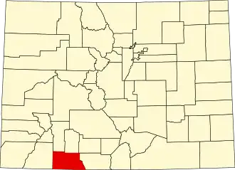 | |
| CDP | ||
| Unincorporated communities | ||
| Ghost towns | ||
| Indian reservation | ||
| Footnotes | ‡This populated place also has portions in an adjacent county or counties | |