Alto Alegre dos Parecis
Alto Alegre dos Parecis | |
|---|---|
 Flag  Coat of arms | |
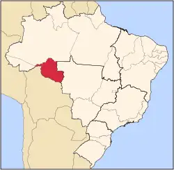
 Location in Rondônia state | |
 Alto Alegre dos Parecis Location in Brazil | |
| Coordinates: 12°7′40″S 61°51′3″W / 12.12778°S 61.85083°W | |
| Country | Brazil |
| Region | North |
| State | Rondônia |
| Area | |
• Total | 3,958 km2 (1,528 sq mi) |
| Population (2020 [1]) | |
• Total | 13,255 |
| • Density | 3.3/km2 (8.7/sq mi) |
| Time zone | UTC−4 (AMT) |
Alto Alegre dos Parecis (Portuguese: [ˈawtu aˈlɛgɾi dus paɾeˈsis]) is a municipality located in the Brazilian state of Rondônia. Its population was 13,255 (2020) and its area is 3,958 km².[2]
The municipality contains 20% of the 384,055 hectares (949,020 acres) Corumbiara State Park, created in 1990.[3] It also contained the 38,950 hectares (96,200 acres) Serra dos Parecis State Park, created in 1990 and cancelled in 2010.[4]
See also
References
- ^ IBGE 2020
- ^ IBGE - [1]
- ^ PES de Corumbiara (in Portuguese), ISA: Instituto Socioambiental, retrieved 2016-10-31
{{citation}}: CS1 maint: publisher location (link) - ^ Legislação Estadual (in Portuguese), Ministério Público do Estado de Rondônia, retrieved 2016-12-10