Ak Komelik, Arizona
Ak Komelik, Arizona | |
|---|---|
Populated place | |
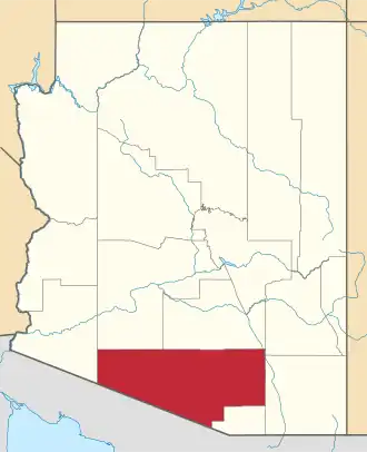
 Ak Komelik, Arizona Location of Ak Komelik in Arizona | |
| Coordinates: 31°43′04″N 112°12′04″W / 31.71778°N 112.20111°W | |
| Country | United States |
| State | Arizona |
| County | Pima |
| Elevation | 2,034 ft (620 m) |
| Time zone | UTC-7 (Mountain (MST)) |
| • Summer (DST) | UTC-7 (MST) |
| Area code | 520 |
| FIPS code | 04-01125 |
| GNIS feature ID | 24297 |
Ak Komelik is a populated place located in Pima County, Arizona.[2] It is a village in the area of the Baboquivari Peak Wilderness in the Papago Indian Reservation.[3] The name means "flats" in the Papago language.[4] The Jesuit missionary Eusebio Kino is believed to have visited the village in 1698 and called it "Cubit Tubig".[4] It has an estimated elevation of 2,034 feet (620 m) above sea level.
References
- ^ "Feature Detail Report for: Ak Komelik". Geographic Names Information System. United States Geological Survey, United States Department of the Interior.
- ^ "Ak Komelik (in Pima County, AZ) Populated Place Profile". AZ Hometown Locator. Retrieved December 13, 2015.
- ^ Place Names on the Papago, Gila Bend and San Xavier Indian Reservations, Volume 2. U.S. Department of the Interior, Office of Indian Affairs. 1941. p. 1.
- ^ a b Barnes, Will C. (1960). Arizona Place Names. Tucson, Arizona: University of Arizona Press. p. 269. LCCN 59063657.