Aikshaw
| Aikshaw | |
|---|---|
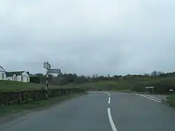 The B5301 running through Aikshaw, with a side road leading to Abbeytown. | |
| OS grid reference | NY123462 |
| Civil parish | |
| Unitary authority | |
| Ceremonial county | |
| Region | |
| Country | England |
| Sovereign state | United Kingdom |
| Post town | WIGTON |
| Postcode district | CA7 |
| Dialling code | 01697 |
| Police | Cumbria |
| Fire | Cumbria |
| Ambulance | North West |
| UK Parliament | |
Aikshaw is a hamlet in the civil parish of Holme St. Cuthbert in Cumbria, United Kingdom. It is located approximately one-and-a-half miles north-west of the village of Westnewton, and three miles east of the village of Mawbray. Jericho is located approximately one mile to the east, with Edderside approximately a mile further to the south-east. Mealrigg is located half-a-mile to the south. Carlisle, Cumbria's county town, is located approximately twenty-two-and-a-half miles to the north-west. Aikshaw lies on the B5301 road, which runs from Silloth-on-Solway in the east via Tarns, Westnewton, and Aspatria to the A595 between Cockermouth and Bothel.[1]
Toponymy
The name of Aikshaw is derived from the Old English eik-sceaga, meaning an oak wood. Archaic variant spellings include Aykesom, Aikeshawehil, and Aikeshaw.[2]
References
- ^ "Google Maps - location of Aikshaw". Retrieved 23 July 2015.
- ^ Holme St. Cuthbert History Group (2004). Plain People: Bygone Times on the Solway Plain. ISBN 0954882318.