Ada Township, Perkins County, South Dakota
Ada Township, South Dakota | |
|---|---|
 Ada Township Location within South Dakota  Ada Township Location within the United States | |
| Coordinates: 45°20′38″N 102°24′39″W / 45.34389°N 102.41083°W | |
| Country | United States |
| State | South Dakota |
| County | Perkins |
| Area | |
• Total | 35.6 sq mi (92.3 km2) |
| • Land | 35.4 sq mi (91.8 km2) |
| • Water | 0.2 sq mi (0.5 km2) |
| Elevation | 2,484 ft (757 m) |
| Population (2000) | |
• Total | 23 |
| • Density | 0.6/sq mi (0.3/km2) |
| Time zone | UTC-7 (Mountain (MST)) |
| • Summer (DST) | UTC-6 (MDT) |
| ZIP code | 57620 |
| Area code | 605 |
| FIPS code | 46-00220[1] |
| GNIS feature ID | 1269024[2] |
Ada (ZIP code 57644) is a rural township in Perkins County, South Dakota, with a population of 557.
References
- ^ "U.S. Census website". United States Census Bureau. Retrieved January 31, 2008.
- ^ "US Board on Geographic Names". United States Geological Survey. October 25, 2007. Retrieved January 31, 2008.
Municipalities and communities of Perkins County, South Dakota, United States | ||
|---|---|---|
| City | 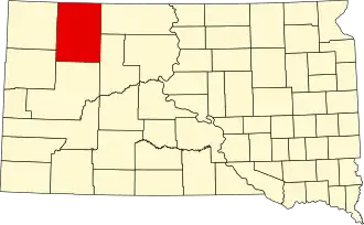 | |
| Town | ||
| Townships |
| |
| CDP | ||
| Other communities | ||
| Ghost towns | ||
| Indian reservation | ||
| Footnotes | ‡This populated place also has portions in an adjacent county or counties | |