Abali
Abali
Persian: آبعلي | |
|---|---|
City | |
 Landscape in the city of Abali | |
 Abali | |
| Coordinates: 35°46′11″N 51°58′00″E / 35.76972°N 51.96667°E[1][2] | |
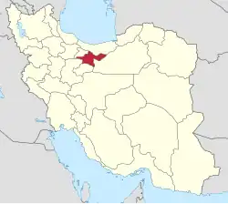
| Country | Iran |
| Province | Tehran |
| County | Damavand |
| District | Rudehen |
| Established as a city | 2005[3] |
| Population (2016)[4] | |
• Total | 2,758 |
| Time zone | UTC+3:30 (IRST) |
Abali (Persian: آبعلي)[a] is a city in Rudehen District of Damavand County, Tehran province, Iran, serving as the administrative center for Abali Rural District.[5] In 2005, the village of Abali merged with the village of Mobarakabad (مبارکآباد) and the population centers of Sarpulak (سرپولک) and Qaim Mahalleh (قایممحله) (also known as Qapuz Mahalleh [قاپوزمحله]) to form the city of Abali.[3]
Demographics
Population
At the time of the 2006 National Census, the city's population was 2,607 in 727 households.[6] The following census in 2011 counted 2,522 people in 766 households.[7] The 2016 census measured the population of the city as 2,758 people in 875 households.[4]
Climate
| Climate data for Abali ( normals 1983-2010, extremes and rain/snow days 1983-2005 ) | |||||||||||||
|---|---|---|---|---|---|---|---|---|---|---|---|---|---|
| Month | Jan | Feb | Mar | Apr | May | Jun | Jul | Aug | Sep | Oct | Nov | Dec | Year |
| Record high °C (°F) | 10.2 (50.4) |
11.0 (51.8) |
16.2 (61.2) |
22.8 (73.0) |
25.4 (77.7) |
30.5 (86.9) |
31.6 (88.9) |
32.2 (90.0) |
28.0 (82.4) |
22.8 (73.0) |
15.6 (60.1) |
16.2 (61.2) |
32.2 (90.0) |
| Mean daily maximum °C (°F) | 0.3 (32.5) |
1.1 (34.0) |
4.9 (40.8) |
11.5 (52.7) |
16.7 (62.1) |
23.1 (73.6) |
26.3 (79.3) |
25.9 (78.6) |
21.9 (71.4) |
14.9 (58.8) |
7.4 (45.3) |
2.4 (36.3) |
13.0 (55.4) |
| Daily mean °C (°F) | −3.7 (25.3) |
−2.9 (26.8) |
1.0 (33.8) |
7.2 (45.0) |
12.1 (53.8) |
17.8 (64.0) |
21.1 (70.0) |
20.6 (69.1) |
16.7 (62.1) |
10.4 (50.7) |
3.6 (38.5) |
−1.3 (29.7) |
8.6 (47.4) |
| Mean daily minimum °C (°F) | −7.6 (18.3) |
−6.9 (19.6) |
−2.9 (26.8) |
2.9 (37.2) |
7.5 (45.5) |
12.6 (54.7) |
15.8 (60.4) |
15.3 (59.5) |
11.5 (52.7) |
5.8 (42.4) |
−0.1 (31.8) |
−4.9 (23.2) |
4.1 (39.3) |
| Record low °C (°F) | −19.0 (−2.2) |
−18.8 (−1.8) |
−26.6 (−15.9) |
−9.5 (14.9) |
−4.6 (23.7) |
0.5 (32.9) |
6.0 (42.8) |
6.0 (42.8) |
3.0 (37.4) |
−3.6 (25.5) |
−12.0 (10.4) |
−16.5 (2.3) |
−26.6 (−15.9) |
| Average precipitation mm (inches) | 63.2 (2.49) |
74.4 (2.93) |
96.7 (3.81) |
66.1 (2.60) |
44.5 (1.75) |
10.8 (0.43) |
10.9 (0.43) |
9.5 (0.37) |
7.5 (0.30) |
24.5 (0.96) |
57.3 (2.26) |
67.0 (2.64) |
532.4 (20.97) |
| Average rainy days | 12.4 | 12.6 | 14.9 | 11.9 | 10.9 | 3.8 | 4.6 | 2.2 | 2.0 | 6.0 | 10.5 | 12.3 | 104.1 |
| Average snowy days | 11.9 | 11.8 | 11.7 | 3.4 | 0.7 | 0 | 0 | 0 | 0 | 0.6 | 5.9 | 11.7 | 57.7 |
| Average relative humidity (%) | 66 | 66 | 62 | 52 | 44 | 33 | 32 | 31 | 32 | 44 | 58 | 66 | 49 |
| Mean monthly sunshine hours | 170.4 | 163 | 179.7 | 209.1 | 270 | 326 | 325.5 | 333.1 | 305.1 | 252.6 | 179.5 | 160 | 2,874 |
| Source: Iran meteorological organization[8] | |||||||||||||
Gallery
-
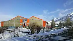 Ab'ali ski resort inside
 -

See also
![]() Media related to Abali at Wikimedia Commons
Media related to Abali at Wikimedia Commons
Notes
References
- ^ OpenStreetMap contributors (18 September 2024). "Mobarak Abad, Abali, Rudehen District, Damavand County, Tehran Province, Iran" (Map). OpenStreetMap (in Persian). Retrieved 18 September 2024.
- ^ "QX98+VMM Abali, Tehran Province, Iran" (Map). Google Maps. Retrieved 23 June 2025.
- ^ a b Aref, Mohammad Reza (15 March 2005) [تاریخ تصویب (Approval date) 1383/12/25 (Iranian Jalali calendar)]. اصلاح تقسیماتی در روستای آبعلی از توابع بخش رودهن شهرستان دماوند در استان تهران [Amendment of divisions in the village of Abali, one of the functions of Rudehen District, Damavand County, Tehran province]. لام تا کام [Lam ta Kam] (in Persian). وزارت کشور [Ministry of the Interior]. کمیسیون سیاسی دفاعی هیأت دولت [Political Defense Commission of the Government Board]. شناسه [ID] 75E5502A-57A0-42C8-ACB2-1D3A5876D5BE. Archived from the original on 23 June 2025. Retrieved 23 June 2025.
- ^ a b سرشماري عمومي نفوس و مسكن 1395 : استان تهران [General Population and Housing Census 2016: Tehran Province]. مرکز آمار ایران [Statistical Centre of Iran] (in Persian). Archived from the original (Excel) on 12 December 2021. Retrieved 23 June 2025.
- ^ Mousavi, Mir-Hossein (9 August 1987) [تاریخ تصویب (Approval date) 1366/05/18 (Iranian Jalali calendar)]. ایجاد و تشکیل تعداد 8 دهستان شامل روستاها، مزارع و مکانها در شهرستان دماوند تابع استان تهران [Creation and formation of eight rural districts including villages, farms and places in Damavand County under Tehran province]. لام تا کام [Lam ta Kam] (in Persian). وزارت کشور [Ministry of the Interior]. هیات وزیران [Council of Ministers]. شناسه [ID] E75F6293-B789-4BB9-85FB-26FE59E88042. شماره دوره [Course number] 66, شماره جلد [Volume number] 11. Archived from the original on 21 June 2025. Retrieved 21 June 2025.
- ^ سرشماري عمومي نفوس و مسكن 1385 : استان تهران [General Population and Housing Census 2006: Tehran Province]. مرکز آمار ایران [Statistical Centre of Iran] (in Persian). Archived from the original (Excel) on 20 September 2011. Retrieved 23 June 2025.
- ^ سرشماري عمومي نفوس و مسكن 1390 : استان تهران [General Population and Housing Census 2011: Tehran Province]. Iran Data Portal—Syracuse University (in Persian). مرکز آمار ایران [Statistical Centre of Iran]. Archived from the original (Excel) on 20 January 2023. Retrieved 23 June 2025.
- ^ "Statistics of 166 synoptic station in the country until the end of 2010 + 37 stations until the end of 2005" آمار 166 ايستگاه سينوپتيك كشور تا پایان سال 2010 میلادی + 37 ایستگاه تا پایان سال 2005. Chaharmahalmet (in Persian). IRIMO. Archived from the original on 17 February 2016. Retrieved 23 January 2024.
| Capital | |||||||||||||||||||||||
|---|---|---|---|---|---|---|---|---|---|---|---|---|---|---|---|---|---|---|---|---|---|---|---|
| Districts |
| ||||||||||||||||||||||