Štítov
Štítov | |
|---|---|
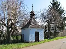 Chapel of the Visitation of Our Lady | |
 Flag  Coat of arms | |
 Štítov Location in the Czech Republic | |
| Coordinates: 49°39′58″N 13°40′41″E / 49.66611°N 13.67806°E | |
| Country | |
| Region | Plzeň |
| District | Rokycany |
| First mentioned | 1460 |
| Area | |
• Total | 2.62 km2 (1.01 sq mi) |
| Elevation | 533 m (1,749 ft) |
| Population (2025-01-01)[1] | |
• Total | 51 |
| • Density | 19/km2 (50/sq mi) |
| Time zone | UTC+1 (CET) |
| • Summer (DST) | UTC+2 (CEST) |
| Postal code | 338 43 |
| Website | www |
Štítov (Czech pronunciation: [ˈʃciːtof]) is a municipality and village in Rokycany District in the Plzeň Region of the Czech Republic. It has about 50 inhabitants.
Štítov lies approximately 12 kilometres (7 mi) south-east of Rokycany, 24 km (15 mi) east of Plzeň, and 71 km (44 mi) south-west of Prague.
Demographics
| Year | Pop. | ±% |
|---|---|---|
| 1869 | 194 | — |
| 1880 | 199 | +2.6% |
| 1890 | 204 | +2.5% |
| 1900 | 178 | −12.7% |
| 1910 | 147 | −17.4% |
| 1921 | 157 | +6.8% |
| 1930 | 160 | +1.9% |
| 1950 | 92 | −42.5% |
| 1961 | 91 | −1.1% |
| 1970 | 86 | −5.5% |
| 1980 | 54 | −37.2% |
| 1991 | 57 | +5.6% |
| 2001 | 54 | −5.3% |
| 2011 | 59 | +9.3% |
| 2021 | 44 | −25.4% |
| Source: Censuses[2][3] | ||
References
- ^ "Population of Municipalities – 1 January 2025". Czech Statistical Office. 2025-05-16.
- ^ "Historický lexikon obcí České republiky 1869–2011" (in Czech). Czech Statistical Office. 2015-12-21.
- ^ "Population Census 2021: Population by sex". Public Database. Czech Statistical Office. 2021-03-27.
External links
Wikimedia Commons has media related to Štítov.